Public Member Functions |
| | DtMgrsCoordinateDisplay (const DtCoordinateSystem &cs) |
| virtual | ~DtMgrsCoordinateDisplay () |
| DtCoordinateDisplay * | clone () const |
| | Virtual clone function.
|
| virtual DtUnicode | name () |
virtual
makArchives::DtDisplayUnitsSettingsRecord::DistanceUnits | xUnitsFor (makArchives::DtDisplayUnitsSettingsRecord::DistanceUnits units) |
virtual
makArchives::DtDisplayUnitsSettingsRecord::DistanceUnits | yUnitsFor (makArchives::DtDisplayUnitsSettingsRecord::DistanceUnits units) |
virtual
makArchives::DtDisplayUnitsSettingsRecord::DistanceUnits | zUnitsFor (makArchives::DtDisplayUnitsSettingsRecord::DistanceUnits units) |
| virtual DtUnicode | xAxisLabel () |
| virtual DtUnicode | yAxisLabel () |
| virtual DtUnicode | zAxisLabel () |
| virtual DtUnicode | gridBoxLabel (const DtVector &lowerLeftGeocPos, const DtVector &upperRightGeocPos) |
| | Some systems (such as MGRS) are not just positions but boxes with grid designators.
|
| virtual DtUnicode | northSouthGridLabel (makArchives::DtDisplayUnitsSettingsRecord::DistanceUnits unit, const DtVector &geocPos, int decimals, double gridSpacing) |
| | Get the label for a north/south grid line at geocPos.
|
| virtual DtUnicode | eastWestGridLabel (makArchives::DtDisplayUnitsSettingsRecord::DistanceUnits unit, const DtVector &geocPos, int decimals, double gridSpacing) |
| | Get the label for an east/west grid line at geocPos.
|
| virtual bool | clipXToGrid (double inStartX, double inEndX, double constantY, double &clippedStartX, double &clippedEndX) |
| | Clip a line segment in LOCAL coordinates to an existing grid defined by this coord system, if any.
|
| virtual bool | clipYToGrid (double inStartY, double inEndY, double constantX, double &clippedStartY, double &clippedEndY) |
| | Returns false if entire segment is outside grid.
|
| virtual double | maxGridSpacing () const |
| | Maximum grid spacing allowed. 0. returned if unlimited.
|
| virtual double | minGridSpacing () const |
| | Minimum grid spacing allowed. 0. returned if unlimited.
|
| virtual std::vector< std::string > | convertPositionToStringList (makArchives::DtDisplayUnitsSettingsRecord::DistanceUnits unit, const DtVector &geocPos, int decimals) |
| | Convert the geocentric position to formatted strings.
|
| virtual void | convertToGeocentric (const std::string &x, const std::string &y, const std::string &z, makArchives::DtDisplayUnitsSettingsRecord::DistanceUnits distUnits, makArchives::DtDisplayUnitsSettingsRecord::DistanceUnits altUnits, DtVector &vector) |
| | Converts the given coordinates (in string rep) from the base units to geocentric.
|
| virtual void | regularExpressionValidator (std::string &x, std::string &y, std::string &z) |
| | Returns a the regexes for validating the XYZ values for this coord sys.
|
| | DtUtmCoordinateDisplay (const DtCoordinateSystem &cs) |
| virtual | ~DtUtmCoordinateDisplay () |
| virtual void | shiftGridLineAnchors (double xSpacing, double ySpacing, double &shiftX, double &shifY) |
| | Normally, grid lines are started at database 0,0.
|
| virtual bool | usesDecimalsOnGridLines () const |
| | Enable/disable the decimals spinbox on grid settings dialog.
|
| virtual DtVector | convertFromGeocentric (const DtVector &geoc) const |
| | Converts the given coordinates from geocentric to local.
|
| virtual DtTaitBryan | localOrientationFor (const DtVector &location, const DtTaitBryan &geocOri) const |
| | Return local orientation given geocentric orientation.
|
| virtual DtTaitBryan | headingPitchRollFor (const DtVector &location, const DtTaitBryan &geocOri) const |
| | Return orientation in radians.
|
| virtual DtDcm | geocToUtmMatrix (const DtVector &geocLoc) const |
| | Rotation matrices based on geocentric location.
|
| virtual DtDcm | utmToGeocMatrix (const DtVector &geocLoc) const |
| virtual bool | isNonUtmDatabase () const |
| | Returns true if inverse flattening is not UTM (.9996)
|
| virtual bool | isGlobalUtmInitialized () const |
| virtual double | scaleFactor () const |
| | DtGeocentricCoordinateDisplay (const DtCoordinateSystem &cs) |
| virtual | ~DtGeocentricCoordinateDisplay () |
| virtual DtVector | geocToLocalVector (const DtVector &geocLoc, const DtVector &geocVec) const |
| | DtCoordinateDisplay (const DtCoordinateSystem &coordSys) |
| | CTOR DtUnitConverterCollection is a collection of classes used to convert between different units (meters, feet, miles, etc.) DtCoordinateSystem is used to do coordinate system conversions, when possible.
|
| virtual | ~DtCoordinateDisplay () |
| | DTOR.
|
| virtual DtUnicode | northSouthGridLabel (OrientationUnits unit, const DtVector &geocPos, int decimals, double gridSpacing) |
| | Get a north / south label with angular units.
|
| virtual DtUnicode | eastWestGridLabel (OrientationUnits unit, const DtVector &geocPos, int decimals, double gridSpacing) |
| | Get an east / west label with angular units.
|
| virtual DtTaitBryan | topoOrientationFor (const DtVector &geocPos, const DtTaitBryan &geocOri) const |
const
SupportedPositionDistanceUnits & | supportedPositionDistanceUnits () const |
| | Retrieve the the list of DistanceUnits supported by this cs display for displaying positions (coordnates).Different coordinate displays can support different distance units for position display (or, in some cases, none).
|
| bool | isSupportedPositionUnit (DistanceUnits unit) const |
| | Determine if the specified distance unit is supported.
|
| void | addSupportedPositionUnit (DistanceUnits unitToSupport) |
| | Add support for a new distance unit type.
|
| void | removeSupportedPositionUnit (DistanceUnits unitToRemove) |
| | Remove support for a distance unit type.
|
const
SupportedPositionAngularUnits & | supportedPositionAngularUnits () const |
| | Retrieve the the list of OrientationUnits supported by this cs display.
|
| bool | isSupportedPositionUnit (OrientationUnits unit) const |
| | Determine if the specified distance unit is supported.
|
| void | addSupportedPositionUnit (OrientationUnits unitToSupport) |
| | Add support for a new distance unit type.
|
| void | removeSupportedPositionUnit (OrientationUnits unitToRemove) |
| | Remove support for a distance unit type.
|
| const SupportedCSForGridLines & | supportedCSForGridLines () const |
| | Retrieve the the list of coordinate systems that can have grid lines drawn using this display type.
|
| bool | isSupportedCSForGridLines (const std::string &cs) const |
| | Determine if this display supports grid lines for the specified coordinate system.
|
| void | addSupportedCSForGridLines (const std::string &cs) |
| | Add grid line support for a coordinate system.
|
| void | removeSupportedCSForGridLines (const std::string &cs) |
| | Remove grid line support for a coordinate system.
|
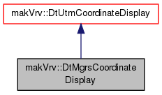
The military grid reference system coordinate system conversion for the GUI.

 Public Member Functions inherited from makVrv::DtUtmCoordinateDisplay