 |
VR-Forces 4.1 Class Documentation
|
|
VR-Forces 4.1 Class Documentation
|
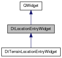
class DtLocationEntryWidget: More...
Public Slots | |
| virtual void | updateUnits (const DtUnitDisplayManager *u) |
| Updates the units and redisplays the labels. | |
| virtual void | updateCoordinateSystem (const DtCoordSys &system) |
| Updates the display of the coordinates. | |
| virtual void | updateCoordinateSystem (const QString &system) |
| virtual void | updateUnitDisplay (const QString &, const QString &, const QString &) |
| virtual void | pointChanged () |
| Received when text in any text box changes. | |
| virtual void | updateLabels () |
Signals | |
| void | locationChanged (DtLocationEntryWidget *wgt, const DtPoint &pnt) |
| Point is in meters. | |
| void | unitsUpdated () |
| Signal when units are updated for this widget. | |
| void | altitudeSelectionChanged (int, double) |
Public Member Functions | |
| DtLocationEntryWidget (QWidget *parent=NULL, const Qt::WindowFlags &f=0) | |
| default constructor | |
| virtual | ~DtLocationEntryWidget () |
| destructor | |
| virtual void | clearPointEdit () |
| Clears out the x, y and z coordinates. | |
| virtual void | hideZ () |
| Hides the Z label and text entry. | |
| virtual void | showZ () |
| Shows the Z label and text entry. | |
| virtual void | getValues (double &x, double &y, double &z) |
| Returns the x, y, and Z values in the buffers given. | |
| virtual void | setValues (double x, double y, double z) |
| virtual void | setValues (const DtStringLocation &loc) |
| virtual bool | zIsVisible () const |
| Returns true if the Z label/text is shown. | |
| virtual QString | xText (bool keepSingleLine=true) const |
| Returns text contents of field If in single line mode, keep the text as is, else break it up into the x component. | |
| virtual QString | yText () const |
| virtual QString | zText () const |
| virtual void | setFromSource (const DtPoint &pnt) |
| Sets the x, y, and z values from source (local) point. | |
| virtual QString | xLabel () const |
| Returns text contents of labels. | |
| virtual QString | yLabel () const |
| virtual QString | zLabel () const |
| virtual QLabel * | xLabelWidget () const |
| virtual QLabel * | yLabelWidget () const |
| virtual QLabel * | zLabelWidget () const |
| virtual void | setXLabel (const QString &) |
| Sets labels. | |
| virtual void | setYLabel (const QString &) |
| virtual void | setZLabel (const QString &) |
| virtual void | setXText (QString x) |
| virtual void | setYText (QString y) |
| virtual void | setZText (QString z) |
| virtual void | setReadOnly (bool b) |
| virtual bool | init (const DtCoordinateSystemCollection *c, const DtUnitDisplayManager *units, const DtCoordSys &system) |
| Initializes widget with specific coordinate system and unit. | |
| virtual void | initConnections () |
| Initializes connections to capture changes to display options. | |
| virtual void | convertFromSource (const DtPoint &pnt, const DtCoordSys &newSys, DtStringLocation &out) |
| Converts from source coordinate system (as found in the terrain database, if it exists) to supplied coordinate system. | |
| virtual void | convertToSource (const DtStringLocation &in, double &x, double &y, double &z) |
| Converts from current coordinate system to coordinate system of database (if there is a terrain database). | |
| virtual void | setSingleLine (bool b) |
| Puts all information into a single line separated by brackets. | |
| virtual void | setSignalChanges (bool b) |
| Call to either emit changes in the location (in the form of a DtPoint) in in meters or turn off those emissions. | |
| virtual void | setUseAltitudeSelection (bool, bool update=true) |
| For those that do it, allow the user to select polygons or height. | |
| bool | useAltitudeSelection () const |
| virtual void | setShowHeightAboveTerrain (bool, double t=-1) |
| bool | showHeightAboveTerrain () const |
| virtual double | heightAboveTerrain () const |
| virtual bool | useHeightAboveTerrain () const |
| virtual bool | useAltitude () const |
| virtual double | altitude () const |
| void | setCalculateOffset (bool) |
| bool | calculateOffset () const |
| virtual double | convertAltitudeToDisplay (double z) const |
| Utility routines to map a Z value (altitude or height) to/from display units to meters. | |
| virtual double | convertAltitudeFromDisplay (double z) const |
Static Public Member Functions | |
| static DtLocationEntryWidget * | create (QWidget *parent=NULL, const Qt::WindowFlags &f=0) |
Public Attributes | |
| Ui::LocationEntryWidgetUi | myUiImpl |
Protected Member Functions | |
| virtual void | hideLayout (QLayout *layout) |
| virtual void | updateDistanceValues (const QString &oldUnits, const QString &newUnits) |
| virtual void | updateAltitudeValue (const QString &oldUnits, const QString &newUnits) |
| virtual void | updateValuesForNewCoordinateSystem (const DtCoordSys &oldSys, const DtCoordSys &newSys) |
| virtual QString | localZText () const |
Protected Attributes | |
| QDoubleValidator | myDoubleValidator |
| DtCoordSys | myCoordinateSystem |
| bool | mySingleLineMode |
| const DtCoordinateSystemCollection * | myCoordinateSystemCollection |
| const DtUnitDisplayManager * | myUnitDisplayManager |
| bool | myUseAltitudeSelection |
| bool | myShowHeightAboveTerrain |
| bool | myCalculateOffset |
| double | myHeightAboveTerrain |
| bool | myZIsHidden |
class DtLocationEntryWidget:
Instances of DtLocationEntryWidget are
| DtLocationEntryWidget::DtLocationEntryWidget | ( | QWidget * | parent = NULL, |
| const Qt::WindowFlags & | f = 0 |
||
| ) |
default constructor
|
virtual |
destructor
|
static |
Reimplemented in DtTerrainLocationEntryWidget.
|
virtual |
Clears out the x, y and z coordinates.
Reimplemented in DtTerrainLocationEntryWidget.
|
virtual |
Hides the Z label and text entry.
Reimplemented in DtTerrainLocationEntryWidget.
|
virtual |
Shows the Z label and text entry.
Reimplemented in DtTerrainLocationEntryWidget.
|
virtual |
Returns the x, y, and Z values in the buffers given.
|
virtual |
|
virtual |
Reimplemented in DtTerrainLocationEntryWidget.
|
virtual |
Returns true if the Z label/text is shown.
Reimplemented in DtTerrainLocationEntryWidget.
|
virtual |
Returns text contents of field If in single line mode, keep the text as is, else break it up into the x component.
In single line mode all text is kept on the x line
|
virtual |
|
virtual |
Reimplemented in DtTerrainLocationEntryWidget.
|
virtual |
Sets the x, y, and z values from source (local) point.
Uses internal settings of coordinate system and units
|
virtual |
Returns text contents of labels.
|
virtual |
|
virtual |
|
virtual |
|
virtual |
|
virtual |
|
virtual |
Sets labels.
|
virtual |
|
virtual |
|
virtual |
|
virtual |
|
virtual |
Reimplemented in DtTerrainLocationEntryWidget.
|
virtual |
Reimplemented in DtTerrainLocationEntryWidget.
|
virtual |
Initializes widget with specific coordinate system and unit.
Reimplemented in DtTerrainLocationEntryWidget.
|
virtual |
Initializes connections to capture changes to display options.
Do not make this call if you want to handle such changes yourself
Reimplemented in DtTerrainLocationEntryWidget.
|
virtual |
Converts from source coordinate system (as found in the terrain database, if it exists) to supplied coordinate system.
Default implementation copies in to out point
Reimplemented in DtTerrainLocationEntryWidget.
|
virtual |
Converts from current coordinate system to coordinate system of database (if there is a terrain database).
Default simply copies to result
Reimplemented in DtTerrainLocationEntryWidget.
|
virtual |
Puts all information into a single line separated by brackets.
|
virtual |
Call to either emit changes in the location (in the form of a DtPoint) in in meters or turn off those emissions.
For those that do it, allow the user to select polygons or height.
Only implemented by subclass. This class keeps track of the flag
Reimplemented in DtTerrainLocationEntryWidget.
|
inline |
References myUseAltitudeSelection.
|
virtual |
Reimplemented in DtTerrainLocationEntryWidget.
|
inline |
References myShowHeightAboveTerrain.
|
inlinevirtual |
Reimplemented in DtTerrainLocationEntryWidget.
References myHeightAboveTerrain.
|
virtual |
Reimplemented in DtTerrainLocationEntryWidget.
|
virtual |
Reimplemented in DtTerrainLocationEntryWidget.
|
virtual |
Reimplemented in DtTerrainLocationEntryWidget.
|
inline |
References myCalculateOffset.
|
inline |
References myCalculateOffset.
|
virtual |
Utility routines to map a Z value (altitude or height) to/from display units to meters.
|
virtual |
|
virtualslot |
Updates the units and redisplays the labels.
|
virtualslot |
Updates the display of the coordinates.
|
virtualslot |
|
virtualslot |
|
virtualslot |
Received when text in any text box changes.
|
virtualslot |
Reimplemented in DtTerrainLocationEntryWidget.
|
signal |
Point is in meters.
|
signal |
Signal when units are updated for this widget.
|
signal |
|
protectedvirtual |
|
protectedvirtual |
|
protectedvirtual |
|
protectedvirtual |
|
protectedvirtual |
Reimplemented in DtTerrainLocationEntryWidget.
| Ui::LocationEntryWidgetUi DtLocationEntryWidget::myUiImpl |
|
protected |
|
protected |
Referenced by DtTerrainLocationEntryWidget::setTerrainDatabase().
|
protected |
|
protected |
|
protected |
|
protected |
Referenced by useAltitudeSelection().
|
protected |
Referenced by showHeightAboveTerrain().
|
protected |
Referenced by calculateOffset(), and setCalculateOffset().
|
protected |
Referenced by heightAboveTerrain().
|
protected |