 |
VR-Forces 4.1 Class Documentation
|
|
VR-Forces 4.1 Class Documentation
|
This class will draw contour lines on the specified terrain. More...
Public Member Functions | |
| DtTerrainGridLineDrawer () | |
| DtTerrainGridLineDrawer (const DtTerrainGridLineDrawer &) | |
| virtual | ~DtTerrainGridLineDrawer () |
| DtTerrainGridLineDrawer & | operator= (const DtTerrainGridLineDrawer &) |
| Note that both the copy constructor and = operator simply copy the pointer to the coordiate system. | |
| void | setManualGridLineFrequency (double d) |
| double | manualGridLineFrequency () const |
| void | setManualMode (bool) |
| Default is false. Manual mode will draw grid lines at a fixed distance rather than a ratio distance. | |
| bool | manualMode () const |
| void | setGridLineColor (const QColor &) |
| const QColor & | gridLineColor () const |
| void | setGridLineLabelColor (const QColor &) |
| const QColor & | gridLineLabelColor () const |
| void | setCoordinateSystem (const DtCoordinateSystem *) |
| Sets new coordinate system. | |
| const DtCoordinateSystem * | coordinateSystem () const |
| void | setAutoGridLineFrequency (int) |
| int | autoGridLineFrequency () const |
| virtual void | drawGridLines (const DtTerrainDatabase *, const DtViewportExtents *, DtPrimitiveDrawer *painter) |
| Calls internalDraw to draw grid lines. | |
| void | setDrawScale (DtGridLineDrawer::DtScaleType) |
| Set to true to draw a scale line (distance) and where (lower left or lower right). Will not draw grid labels. | |
| DtGridLineDrawer::DtScaleType | drawScale () const |
| virtual double | autoGridLineIncrement (const DtViewportExtents *v, const DtTerrainDatabase *db) const |
| virtual int | coordinateSystemDrawerType () const |
 Public Member Functions inherited from DtTerrainDrawer Public Member Functions inherited from DtTerrainDrawer | |
| DtTerrainDrawer () | |
| DtTerrainDrawer (const DtTerrainDrawer &) | |
| virtual | ~DtTerrainDrawer () |
| DtTerrainDrawer & | operator= (const DtTerrainDrawer &) |
| virtual void | draw (const DtTerrainDatabase *, const DtViewportExtents *, DtPrimitiveDrawer *painter) |
| Call in order to draw the particular aspect of the terrain on the supplied painter. | |
| void | setDrawingEnabled (bool) |
| Get/set the drawingEnabled flag. | |
| bool | drawingEnabled () const |
Static Public Member Functions | |
| static DtTerrainGridLineDrawer * | create () |
Protected Member Functions | |
| virtual void | internalDraw (const DtTerrainDatabase *, const DtViewportExtents *, DtPrimitiveDrawer *painter) |
| Implement this feature to do specific terrain drawing. | |
| virtual void | drawManualGridLines (const DtTerrainDatabase *db, const DtViewportExtents *v, DtPrimitiveDrawer *painter) |
| virtual void | drawAutoGridLines (const DtTerrainDatabase *db, const DtViewportExtents *v, DtPrimitiveDrawer *painter) |
| virtual void | drawGridLines (const DtPoint &vp_min_WC, const DtPoint &vp_max_WC, double increment, const DtTerrainDatabase *db, const DtViewportExtents *v, DtPrimitiveDrawer *painter) |
| Default calls myCoordinateSystem->gridLineDrawer()->drawGridLines(...) | |
| virtual void | createCoordinateSystem (const DtTerrainDatabase *) |
| Creates unit coordinate system and adds default converters. | |
| virtual void | cleanupCoordinateSystem () |
| Protected Member Functions inherited from DtTerrainDrawer | |
| virtual void | drawExtent (const DtExtent &extent, const DtHomogeneousTransfMatrix &mtx, const DtViewportExtents *v, DtPrimitiveDrawer *painter) |
| Drawing routines. | |
| virtual void | drawFilledPoly (const DtAllTypesPolygon *polygon, const DtHomogeneousTransfMatrix &mtx, const DtViewportExtents *v, DtPrimitiveDrawer *painter) |
| virtual void | drawLine (const DtPoint &gdp0, const DtPoint &gdp1, const DtViewportExtents *view, DtPrimitiveDrawer *painter) |
| virtual void | drawWireframePoly (const DtAllTypesPolygon *polygon, const DtHomogeneousTransfMatrix &mtx, const DtViewportExtents *v, DtPrimitiveDrawer *painter) |
Protected Attributes | |
| double | myManualGridLineFrequency |
| bool | myManualMode |
| QColor | myGridLineColor |
| QColor | myGridLineLabelColor |
| int | myAutoGridLineFrequency |
| const DtCoordinateSystem * | myCoordinateSystem |
| This class is used to convert grid line units between meters and other units (km, ft, etc.). | |
| bool | myOwnsCoordinateSystem |
| DtGridLineDrawer::DtScaleType | myScaleLine |
| Protected Attributes inherited from DtTerrainDrawer | |
| bool | myDrawingEnabled |
This class will draw contour lines on the specified terrain.
| DtTerrainGridLineDrawer::DtTerrainGridLineDrawer | ( | ) |
| DtTerrainGridLineDrawer::DtTerrainGridLineDrawer | ( | const DtTerrainGridLineDrawer & | ) |
|
virtual |
| DtTerrainGridLineDrawer& DtTerrainGridLineDrawer::operator= | ( | const DtTerrainGridLineDrawer & | ) |
Note that both the copy constructor and = operator simply copy the pointer to the coordiate system.
If the object that is passed in has allocated the coordiate system, be aware that if that object deletes it's coordinate system, this will cause the application to exhibit unstable behavior
|
inline |
References myManualGridLineFrequency.
|
inline |
References myManualGridLineFrequency.
|
inline |
Default is false. Manual mode will draw grid lines at a fixed distance rather than a ratio distance.
References myManualMode.
|
inline |
References myManualMode.
|
inline |
References myGridLineColor.
|
inline |
References myGridLineColor.
|
inline |
References myGridLineLabelColor.
|
inline |
References myGridLineLabelColor.
| void DtTerrainGridLineDrawer::setCoordinateSystem | ( | const DtCoordinateSystem * | ) |
Sets new coordinate system.
If the current coordinate system is owned, will delete it and replace it with the new one
|
inline |
References myCoordinateSystem.
|
inline |
References myAutoGridLineFrequency.
|
inline |
References myAutoGridLineFrequency.
|
static |
|
virtual |
Calls internalDraw to draw grid lines.
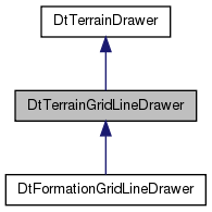
Reimplemented in DtFormationGridLineDrawer.
|
inline |
Set to true to draw a scale line (distance) and where (lower left or lower right). Will not draw grid labels.
References myScaleLine.
|
inline |
References myScaleLine.
|
virtual |
Reimplemented in DtFormationGridLineDrawer.
|
virtual |
|
protectedvirtual |
Implement this feature to do specific terrain drawing.
Implements DtTerrainDrawer.
|
protectedvirtual |
|
protectedvirtual |
|
protectedvirtual |
Default calls myCoordinateSystem->gridLineDrawer()->drawGridLines(...)
Reimplemented in DtFormationGridLineDrawer.
|
protectedvirtual |
Creates unit coordinate system and adds default converters.
|
protectedvirtual |
|
protected |
Referenced by manualGridLineFrequency(), and setManualGridLineFrequency().
|
protected |
Referenced by manualMode(), and setManualMode().
|
protected |
Referenced by gridLineColor(), and setGridLineColor().
|
protected |
Referenced by gridLineLabelColor(), and setGridLineLabelColor().
|
protected |
Referenced by autoGridLineFrequency(), and setAutoGridLineFrequency().
|
protected |
This class is used to convert grid line units between meters and other units (km, ft, etc.).
A coordinate system will be created as part of the first time this class is used to draw if no coordinate system exists
Referenced by coordinateSystem().
|
protected |
|
protected |
Referenced by drawScale(), and setDrawScale().