VR-Forces 4.7 Class Documentation
 All Classes Namespaces Files Functions Variables Typedefs Enumerations Enumerator Properties Friends Macros Groups Pages
List of all members | Classes | Public Types | Public Member Functions | Protected Attributes
makVrv::DtIntersector Class Reference

DtIntersector is an abstract class that provides the interface for requesting intersections with the scene graph. More...

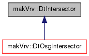
Inheritance diagram for makVrv::DtIntersector:
Inheritance graph
[legend]

Classes

struct  CachedPick
 CachedPick is a container class for the information to cache a pick request. More...

Public Types

enum  IntersectProperties {
  AllNodes = 0, PickableNodes = 1, SupportNodes = 2, NodesThatReceivesShadows = 4,
  NodesThatCastsShadows = 8
}
 The IntersectProperties enum is a flag set that indicates the. More...
enum  DynamicOceanProperties { DynamicOceanPropertyMsl = 0, DynamicOceanPropertyWaves = 1, DynamicOceanPropertyIgnore = 2 }
typedef std::vector
< DtIntersectorResult
DtIntersections
 A vector of DtIntersectionRecords.

Public Member Functions

 DtIntersector (DtDe &de)
 CTOR.
virtual ~DtIntersector ()
 DTOR.
virtual void setDynamicOceanProperties (DynamicOceanProperties properties)
 If an ocean layer exists, determine if it should be ignored, use mean sea level, or wave height.
DynamicOceanProperties dynamicOceanProperties () const
 Return the current dynamic ocean properties.
virtual bool findNearestIntersectionToPoint (double x, double y, double z, double vx, double vy, double vz, DtIntersectorResult &intersection, IntersectProperties properties=AllNodes, std::vector< DtElementID > *ignoreList=0, bool returnTriangle=false, double maxIsectorLength=-1., bool useHighLod=false)=0
 Find the nearest scene intersection from a point (x,y,z) along a vector(vx,vy,vz) The useHighLod argument tells the intersector that if the terrain is an osgEarth terrain, don't settle for whatever is paged in; get the highest LOD from the map server for this location and use that Note that if maxIsectorLength is not set, the default is the diameter of the database, which for large (and especially geocentric) databases and world databases, may be too large to get adequate precision when trying to interect small (high resolution) triangles.
virtual bool findAllIntersectionsThroughPoint (double x, double y, double z, double vx, double vy, double vz, DtIntersections &intersections, IntersectProperties properties=AllNodes, std::vector< DtElementID > *ignoreList=0, bool sort=true, bool useHighLod=false)=0
 Return a list of all intersections along the line passing through <x,y,z> and directed by <vx, vy, vz> The useHighLod argument tells the intersector that if the terrain is an osgEarth terrain, don't settle for whatever is paged in; get the highest LOD from the map server for this location and use that.
virtual bool findFirstIntersectWithLineSegment (double x, double y, double z, double end_x, double end_y, double end_z, DtIntersectorResult &intersection, IntersectProperties properties=AllNodes, std::vector< DtElementID > *ignoreList=0, bool useHighLod=false)=0
 find first intersection along segment x,y,z to end_x, end_y, end_z.
virtual bool findAllIntersectWithLineSegment (double x, double y, double z, double end_x, double end_y, double end_z, DtIntersections &intersections, IntersectProperties properties=AllNodes, std::vector< DtElementID > *ignoreList=0, bool sort=true, bool useHighLod=false)=0
 find all intersections along segment x,y,z to end_x, end_y, end_z.
virtual bool pick (DtChannel &channel, double mx, double my, DtIntersectorResult &intersection, IntersectProperties properties=AllNodes, std::vector< DtElementID > *ignoreList=0)=0
 Find the object (if any) under the mouse mx, my are in window coordinates; cx, cy, cz are returned in database coordinates.
virtual bool pickAll (DtChannel *channel, double mx, double my, DtIntersections &intersections, IntersectProperties properties=AllNodes, std::vector< DtElementID > *ignoreList=0)=0
 Find all the objects (if any) under the mouse mx, my are in window coordinates.
virtual void setDefaultMaxClamp (double maximumIsectorLength)
 For intersectors where no maximum length can be specified, or when no length is provided, VR-Vantage uses the bounding radius of the sceneRoot specified or implied.
virtual double defaultMaxClamp () const

Protected Attributes

DtDemyDe
DynamicOceanProperties myDynamicOceanProperties
CachedPick myLastPick
bool myLastPickSucceeded
DtIntersectorResult myLastResult
double myDefaultMaxClamp

Detailed Description

DtIntersector is an abstract class that provides the interface for requesting intersections with the scene graph.

Member Typedef Documentation

A vector of DtIntersectionRecords.

Member Enumeration Documentation

The IntersectProperties enum is a flag set that indicates the.

types of nodes to be considered for intersections

Enumerator:
AllNodes 
PickableNodes 
SupportNodes 
NodesThatReceivesShadows 
NodesThatCastsShadows 
Enumerator:
DynamicOceanPropertyMsl 
DynamicOceanPropertyWaves 
DynamicOceanPropertyIgnore 

Constructor & Destructor Documentation

makVrv::DtIntersector::DtIntersector ( DtDe de)

CTOR.

virtual makVrv::DtIntersector::~DtIntersector ( )
virtual

DTOR.

Member Function Documentation

virtual void makVrv::DtIntersector::setDynamicOceanProperties ( DynamicOceanProperties  properties)
virtual

If an ocean layer exists, determine if it should be ignored, use mean sea level, or wave height.

DynamicOceanProperties makVrv::DtIntersector::dynamicOceanProperties ( ) const

Return the current dynamic ocean properties.

virtual bool makVrv::DtIntersector::findNearestIntersectionToPoint ( double  x,
double  y,
double  z,
double  vx,
double  vy,
double  vz,
DtIntersectorResult intersection,
IntersectProperties  properties = AllNodes,
std::vector< DtElementID > *  ignoreList = 0,
bool  returnTriangle = false,
double  maxIsectorLength = -1.,
bool  useHighLod = false 
)
pure virtual

Find the nearest scene intersection from a point (x,y,z) along a vector(vx,vy,vz) The useHighLod argument tells the intersector that if the terrain is an osgEarth terrain, don't settle for whatever is paged in; get the highest LOD from the map server for this location and use that Note that if maxIsectorLength is not set, the default is the diameter of the database, which for large (and especially geocentric) databases and world databases, may be too large to get adequate precision when trying to interect small (high resolution) triangles.

It is recommended that you set the isector length to something more specific if possible, like the altitude of the observer + a constant, for example; or, for osgEarth databases, useHighLod=true, which will also eliminate the problem.

Return values
falseif no intersection was found (and the isect record is NOT set).

Implemented in makVrv::DtOsgIntersector.

virtual bool makVrv::DtIntersector::findAllIntersectionsThroughPoint ( double  x,
double  y,
double  z,
double  vx,
double  vy,
double  vz,
DtIntersections intersections,
IntersectProperties  properties = AllNodes,
std::vector< DtElementID > *  ignoreList = 0,
bool  sort = true,
bool  useHighLod = false 
)
pure virtual

Return a list of all intersections along the line passing through <x,y,z> and directed by <vx, vy, vz> The useHighLod argument tells the intersector that if the terrain is an osgEarth terrain, don't settle for whatever is paged in; get the highest LOD from the map server for this location and use that.

Return values
falseif no intersection was found (and the isect record list has size 0).

Implemented in makVrv::DtOsgIntersector.

virtual bool makVrv::DtIntersector::findFirstIntersectWithLineSegment ( double  x,
double  y,
double  z,
double  end_x,
double  end_y,
double  end_z,
DtIntersectorResult intersection,
IntersectProperties  properties = AllNodes,
std::vector< DtElementID > *  ignoreList = 0,
bool  useHighLod = false 
)
pure virtual

find first intersection along segment x,y,z to end_x, end_y, end_z.

The useHighLod argument tells the intersector that if the terrain is an osgEarth terrain, don't settle for whatever is paged in; get the highest LOD from the map server for this location and use that

Return values
falseif no intersection was found (and the isect record is NOT set).

Implemented in makVrv::DtOsgIntersector.

virtual bool makVrv::DtIntersector::findAllIntersectWithLineSegment ( double  x,
double  y,
double  z,
double  end_x,
double  end_y,
double  end_z,
DtIntersections intersections,
IntersectProperties  properties = AllNodes,
std::vector< DtElementID > *  ignoreList = 0,
bool  sort = true,
bool  useHighLod = false 
)
pure virtual

find all intersections along segment x,y,z to end_x, end_y, end_z.

The useHighLod argument tells the intersector that if the terrain is an osgEarth terrain, don't settle for whatever is paged in; get the highest LOD from the map server for this location and use that

Return values
falseif no intersection was found (and the isect record list has size 0).

Implemented in makVrv::DtOsgIntersector.

virtual bool makVrv::DtIntersector::pick ( DtChannel channel,
double  mx,
double  my,
DtIntersectorResult intersection,
IntersectProperties  properties = AllNodes,
std::vector< DtElementID > *  ignoreList = 0 
)
pure virtual

Find the object (if any) under the mouse mx, my are in window coordinates; cx, cy, cz are returned in database coordinates.

Return values
falseif no intersection was found (and the isect record is NOT set).

Implemented in makVrv::DtOsgIntersector.

virtual bool makVrv::DtIntersector::pickAll ( DtChannel channel,
double  mx,
double  my,
DtIntersections intersections,
IntersectProperties  properties = AllNodes,
std::vector< DtElementID > *  ignoreList = 0 
)
pure virtual

Find all the objects (if any) under the mouse mx, my are in window coordinates.

Return values
falseif no intersection was found (and the isect record list has size 0).

Implemented in makVrv::DtOsgIntersector.

virtual void makVrv::DtIntersector::setDefaultMaxClamp ( double  maximumIsectorLength)
virtual

For intersectors where no maximum length can be specified, or when no length is provided, VR-Vantage uses the bounding radius of the sceneRoot specified or implied.

For earth terrains especially, it makes sense to put an upper bound on this. By default, that boundary is the earth's ~diameter - 12.742e+6. This method allows you to expand that (perhaps you intentionally want to intersect the terrain on the other side of the earth, for instance)

virtual double makVrv::DtIntersector::defaultMaxClamp ( ) const
virtual

Member Data Documentation

DtDe& makVrv::DtIntersector::myDe
protected
DynamicOceanProperties makVrv::DtIntersector::myDynamicOceanProperties
protected
CachedPick makVrv::DtIntersector::myLastPick
protected
bool makVrv::DtIntersector::myLastPickSucceeded
protected
DtIntersectorResult makVrv::DtIntersector::myLastResult
protected
double makVrv::DtIntersector::myDefaultMaxClamp
protected

The documentation for this class was generated from the following file:

Document ID: Generated on Fri Apr 26 21:53:14 EDT 2019 from SVN revision 197883
Copyright © 2005-2019 VT MAK. All Rights Reserved (www.mak.com)