 |
VR-Forces 5.0.2 Developer's Guide
|


All Classes Namespaces Files Functions Variables Typedefs Enumerations Enumerator Properties Friends Macros Groups Pages
|
VR-Forces 5.0.2 Developer's Guide
|
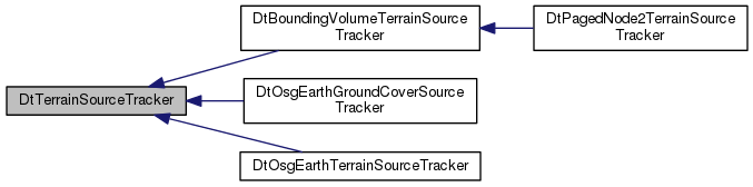
Base class for Terrain Source trackers. Determines if the necessary data To perform an intersection is currently available. Can also create commands for a DtTerrainSourceTracker to actually perform the paging.
| DtTerrainSourceTracker::DtTerrainSourceTracker | ( | DtVantageTerrainEngine * | , |
| DtPagerCommandQueue * | commandQueue, | ||
| osgEarth::MapNode * | mapNode | ||
| ) |
CTOR.
|
virtual |
DTOR.
|
virtual |
|
virtual |
|
virtual |
Called after options are set. Returns false if error.
Reimplemented in DtOsgEarthTerrainSourceTracker, and DtOsgEarthGroundCoverSourceTracker.
|
virtual |
Fidelity that this tracker is configured for. The default returns an empty optional which means that this tracker will be used for all terrain intersections. If value is returned then this tracker will only be used for intersections which specify that fidelity.
Reimplemented in DtOsgEarthTerrainSourceTracker.
|
pure virtual |
Implemented in DtOsgEarthTerrainSourceTracker, DtBoundingVolumeTerrainSourceTracker, DtOsgEarthGroundCoverSourceTracker, and DtPagedNode2TerrainSourceTracker.
|
pure virtual |
Page in data within geometry. Determines which tiles are within the geometry and adds a page in command to myCommandQueue to page in any tiles within the geometry that have not yet been paged in.
| geometry | The geometry to page in data within. |
| intersectId | Id to assign to the page in command to seed tileData for newly paged-in tiles. |
| priority | Priority to use for commands generated by this call. |
Implemented in DtOsgEarthTerrainSourceTracker, DtBoundingVolumeTerrainSourceTracker, DtOsgEarthGroundCoverSourceTracker, and DtPagedNode2TerrainSourceTracker.
|
pure virtual |
|
pure virtual |
Finds the least-recently-used tile and set myOldestPagedObject to it.
| numTrianglesOut | The number of triangles the least-recently-used tileId represents in the collision world. |
Implemented in DtOsgEarthTerrainSourceTracker, DtBoundingVolumeTerrainSourceTracker, DtOsgEarthGroundCoverSourceTracker, and DtPagedNode2TerrainSourceTracker.
|
pure virtual |
Adds a page out command for the least-recently-used tileID to myCommandQueue.
| priority | Priority to use for commands generated by this call. |
Implemented in DtOsgEarthTerrainSourceTracker, DtBoundingVolumeTerrainSourceTracker, DtOsgEarthGroundCoverSourceTracker, and DtPagedNode2TerrainSourceTracker.
|
virtual |
|
virtual |
|
virtual |
|
virtual |
Access osgEarth::MapNode object.
|
virtual |
Access osgEarth::profile object.
|
virtual |
Return the local coordinate system.
|
virtual |
|
virtual |
Reimplemented in DtBoundingVolumeTerrainSourceTracker.
|
virtual |
Return a list of bounding sphere that represent the the paged in tiles.
Reimplemented in DtBoundingVolumeTerrainSourceTracker.
|
virtual |
Return a list of bounding sphere that represent the the paged out tiles.
Reimplemented in DtBoundingVolumeTerrainSourceTracker.
|
virtual |
Return a list of tiles that represent the ground cover loaded.
Reimplemented in DtOsgEarthGroundCoverSourceTracker.
|
virtual |
Reimplemented in DtOsgEarthTerrainSourceTracker.
|
virtual |
Reimplemented in DtOsgEarthTerrainSourceTracker.
|
virtual |
Return true if the current tracker use land cover data.
Reimplemented in DtOsgEarthTerrainSourceTracker.
|
virtual |
Reimplemented in DtOsgEarthTerrainSourceTracker.
|
virtual |
Reimplemented in DtOsgEarthTerrainSourceTracker.
|
virtual |
Reimplemented in DtOsgEarthTerrainSourceTracker.
|
virtual |
Reimplemented in DtOsgEarthTerrainSourceTracker.
|
virtual |
Return the max lod.
Reimplemented in DtOsgEarthGroundCoverSourceTracker, and DtOsgEarthTerrainSourceTracker.
|
virtual |
Return true if the current tracker use raw elevation.
Reimplemented in DtOsgEarthTerrainSourceTracker.
|
virtual |
Return the best tile key to use (based on the tracker) for a pass tilekey.
Reimplemented in DtOsgEarthTerrainSourceTracker.
|
virtual |
Check it the geometry intersect the tileDataCache (when we know the geometry is a chord, pass the chord pointer as the last optional parameters)
|
virtual |
Add a tile that was not find in the cache (by findTileInCache) (when we know the geometry is a chord, pass the chord pointer as the last optional parameters)
|
virtual |
Clear the cache.
|
virtual |
Sets the min LOD levels where elevation tiles can be loaded.
|
virtual |
map node for whole terrain
|
protected |
map node for whole terrain
|
protected |
map node for whole terrain
|
protected |
map node for whole terrain
|
protected |
map node for whole terrain
|
mutableprotected |
map node for whole terrain
|
mutableprotected |
map node for whole terrain
|
protected |
map node for whole terrain
|
protected |
map node for whole terrain
|
protected |
map node for whole terrain
|
protected |
map node for whole terrain
|
protected |
Tile Data cache to speed up intersections.
|
protected |
Stats for cache.
|
protected |
map node for whole terrain
|
protected |
Min lod an elevation tile can loaded.
|
protected |
map node for whole terrain