 |
VR-Forces 5.0.2 Developer's Guide
|


All Classes Namespaces Files Functions Variables Typedefs Enumerations Enumerator Properties Friends Macros Groups Pages
|
VR-Forces 5.0.2 Developer's Guide
|
DtTerrain is a facade around terrain functionality.
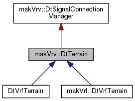
Public Types | |
| typedef std::list < DtTerrainPatch * > | TerrainPatches |
| typedef std::list < DtFeatureLayer * > | FeatureLayers |
| typedef std::list< DtOceanLayer * > | OceanLayers |
| typedef std::map< int, makArchives::DtTerrainOperationRecord > | TerrainOperationsMap |
Protected Types | |
| typedef std::map< std::string, int > | PropNameMap |
Protected Member Functions | |
| void | executeTerrainOperation (const makArchives::DtTerrainOperationRecord &operation, const makArchives::DtTerrainRecord &terrainRec) |
| void | addTerrainOperationRecord (const makArchives::DtTerrainOperationRecord &operation) |
| void | removeTerrainOperationRecord (const makArchives::DtTerrainOperationRecord &operation) |
| void | removeTerrainOperationRecord (int id) |
| void | clearTerrainOperations () |
| void | slot_handleIsDayChanged (bool isDay) |
| virtual bool | checkIfTerrainOperationRecordsMatch (const makArchives::DtTerrainOperationRecord &left, const makArchives::DtTerrainOperationRecord &right) |
| virtual void | connectForestAndOceanSignals (void) |
Additional Inherited Members | |
 Private Types inherited from makVrv::DtSignalConnectionManager Private Types inherited from makVrv::DtSignalConnectionManager | |
| typedef std::vector < boost::signalslib::connection > | Connections |
| Private Member Functions inherited from makVrv::DtSignalConnectionManager | |
| DtSignalConnectionManager () | |
| virtual | ~DtSignalConnectionManager () |
| void | manageConnection (const boost::signalslib::connection &conn) |
| DtSignalConnectionManager & | operator+= (const boost::signalslib::connection &conn) |
| bool | blockConnections (bool blocked) |
| int | numberOfConnections () const |
| void | disconnectSignals () |
| bool | connectionsBlocked () const |
| Private Attributes inherited from makVrv::DtSignalConnectionManager | |
| Connections | myConnections |
| bool | myConnectionsBlocked |
| bool | myIndiviualConnectionedBlocked |
| std::vector < boost::signalslib::shared_connection_block * > | mySharedConnectionsBlockManager |
| typedef std::list<DtTerrainPatch*> makVrv::DtTerrain::TerrainPatches |
| typedef std::list<DtFeatureLayer*> makVrv::DtTerrain::FeatureLayers |
| typedef std::list<DtOceanLayer*> makVrv::DtTerrain::OceanLayers |
| typedef std::map<int, makArchives::DtTerrainOperationRecord> makVrv::DtTerrain::TerrainOperationsMap |
Map of terrain operation ids, to terrain operations.
|
protected |
| makVrv::DtTerrain::DtTerrain | ( | DtDe & | de, |
| DtAgentManagerInterface & | sceneManagerInterface | ||
| ) |
CTOR.
|
virtual |
DTOR.
| void makVrv::DtTerrain::clear | ( | bool | reload = false | ) |
Clear the terrain. If the terrain is being cleared because a reloadTerrain operation was requested, the reload flag will be set to true.
| bool makVrv::DtTerrain::globalScaleTerrain | ( | ) | const |
Checks to see if the terrain is a global scale terrain. Typically a global scale terrain takes a [nearly] complete representation of the globe.
| void makVrv::DtTerrain::updateGlobalScaleTerrain | ( | ) |
Rechecks if the terrain is of global scale. This function will emit the global scale changed signal from the signaler object if the scale changes.
|
virtual |
Fill out a DtTerrainRecord with the current terrain info. Called by saveTerrain().
Reimplemented in makVrf::DtVrfTerrain.
|
virtual |
Populate a DtTerrain from a DtTerrainRecord. Called by loadTerrain(). If the clearFirst flag is true, DtTerrain::clear() will be called before populating the new terrain.
Reimplemented in makVrf::DtVrfTerrain.
|
virtual |
Request that the current terrain be reloaded.
|
virtual |
Create and add a new terrain patch driver. If a terrain patch already exists with the same name, it is deleted. Do not delete this terrain patch via the returned pointer. Instead, use deleteTerrainPatch().
|
virtual |
Create and add a new terrain patch driver. If a terrain patch already exists with the same name, it is deleted, unless minimapOnly is true (we allow the minimap to show the same patch in the main view). If minimapOnly is true and the minimap model set is not realized, the patch itself is still created (so we don't lose it on a subsequent save) but the terrain patch will not create a DtTerrainPatchObject and nothing is loaded/rendered for the patch. Do not delete this terrain patch via the returned pointer. Instead, use deleteTerrainPatch().
|
virtual |
Return the DtTerrainPatchObjectAgent with the name terrainName.
|
virtual |
Return the DtTerrainPatchObjectAgent with the unique id.
|
virtual |
Find and delete a terrain.
| terrainDefinitionName | The definition name of the terrain patch to be removed |
| minimapOnly | Whether the terrain patch being removed is only part of the minimap |
| const TerrainPatches& makVrv::DtTerrain::terrainPatches | ( | ) | const |
Get the terrain drivers. Do not add or remove terrains while iterating.
| TerrainPatches& makVrv::DtTerrain::terrainPatches | ( | ) |
Get the terrain drivers. Do not add or remove terrains while iterating.
| bool makVrv::DtTerrain::lightPointsEnabled | ( | ) | const |
Are we showing point lights on the terrain?
|
virtual |
|
virtual |
Add a feature layer. Calls addFeatureLayer with a given name. It then initializes the feature layer using the provided record.
|
virtual |
Create and add a DtFeatureLayer. If a DtFeatureLayer already exists with the same name, it is deleted. Do not delete this DtFeatureLayer via the returned pointer. Instead, use removeFeatureLayer().
Reimplemented in DtVrfTerrain.
|
virtual |
Remove a feature layer. Emits signal_terrainPatchToBeDeleted.
|
virtual |
Accessor for FeatureLayers.
|
virtual |
Accessor for FeatureLayers.
|
virtual |
Return the DtFeatureLayer with the name featureLayerFilename.
|
virtual |
return the streamed feature layer
contains features streamed in and represented by 3d facades
|
virtual |
Return the buoy layer.
|
virtual |
Return the dynamic feature layer. The dynamic feature layer contains entities which utilize .meta files for configuring and updating specific nodes in a model based on node annotations or node names.
|
virtual |
Return the nav light manager.
|
virtual |
Return the nav daymark manager.
|
virtual |
Return the nav topmark manager.
|
virtual |
Add an ocean layer. Calls addOceanLayer with a given name. It then initializes the ocean layer using the provided record.
|
virtual |
Create and add a DtOceanLayer. If a DtOceanLayer already exists with the same name, it is deleted. Do not delete this DtOceanLayer via the returned pointer. Instead, use removeOceanLayer().
|
virtual |
Remove a ocean layer. Emits signal_oceanLayerToBeDeleted.
|
virtual |
Accessor for OceanLayers.
|
virtual |
Accessor for OceanLayers.
|
virtual |
Return the DtOceanLayer with the name layerName.
|
virtual |
Slot called when ocean nodes are extracted. If there aren't any ocean layers, DtTerrain will create one when this is called.
| std::string makVrv::DtTerrain::generatePropName | ( | const std::string & | propType | ) |
Generate a unique name for the prop.
|
virtual |
Return the DtForestObjectDriver. This lazily creates one if it does not exist. There only needs to be one DtForestObjectDriver for the whole scene.
| bool makVrv::DtTerrain::isPropNameUsed | ( | const std::string & | propName | ) | const |
Checks whether a prop name is in use.
|
virtual |
Get the closest intersection to x,y,z. Note that the up values may not be used in the case of osgEarth patches (it will use the normal to the surface at x,y,z).
|
virtual |
If any of the terrain's patch objects is using an elevation cache, clear them (otherwise do nothing). Use after making a large number of successive calls, such as while extracting props from a shape file.
|
virtual |
Saves terrain geometry and props to specified file. This file will be saved in the format specified by the file extension. Currently only the .gdb extension is supported.
|
virtual |
Find an optional parameter. These optional parameters are provided because VR-Vantage and VR-Forces want to be able to share terrain files, and this makes whole process simpler.
|
virtual |
Set an optional parameter.
|
virtual |
Set an optional parameters. This will overwrite any existing optional parameters.
|
virtual |
Remove an optional parameter.
| const makArchives::DtTerrainRecord::OptionalParameterMap& makVrv::DtTerrain::optionalParameters | ( | ) | const |
Get the optional parameters.
|
virtual |
Get the terrains's description.
|
virtual |
Set the terrains's description.
|
virtual |
Get the UseICO flag.
|
virtual |
Set the UseICO flag.
Set the max paged LOD target.
|
inlinevirtual |
is the terrain currently reloading
|
protected |
Execute a terrain operation. For example, adding a terrain patch.
|
protected |
Add a terrain operations record and emit signal_terrainOperationAdded.
|
protected |
Remove a previously added record.
|
protected |
Removed a terrain operations record and emit signal_terrainOperationAdded.
|
protected |
Remove all terrain operations from myTerrainOperationsMap emitting signals.
|
protected |
Turn on and off the lights when the sky object says to.
|
protectedvirtual |
Check if two DtTerrainOperationRecord match without comparing the application type field.
|
protectedvirtual |
|
protected |
|
protected |
|
protected |
|
protected |
|
protected |
|
protected |
|
protected |
|
protected |
|
protected |
|
protected |
|
protected |
|
protected |
|
protected |
|
protected |
|
protected |
|
protected |
|
protected |
|
protected |
|
protected |
|
protected |
|
protected |
|
protected |
|
protected |