 |
VR-Link API Documentation for HLA 1.3
|
|
VR-Link API Documentation for HLA 1.3
|
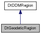
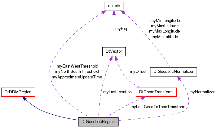
 Inheritance diagram for DtGeodeticRegion: Collaboration diagram for DtGeodeticRegion:
Public Member Functions | |
| DtGeodeticRegion (DtExerciseConn *exConn) | |
| Constructor that uses default space and dimensions. | |
| DtGeodeticRegion (DtExerciseConn *exConn, const std::vector< DtString > &dimensionNamesVector) | |
| Constructor. | |
| DtGeodeticRegion (DtExerciseConn *conn, const std::vector< DtString > &dimensionNamesVector, const DtGeodeticCoord &ddmPlayboxLowerBound, const DtGeodeticCoord &ddmPlayboxUpperBound) | |
| Constructor that takes coordinates. | |
| virtual | ~DtGeodeticRegion () |
| Destructor. | |
| virtual void | setRegionBounds (const DtGeodeticCoord &lowerBound, const DtGeodeticCoord &upperBound) |
| Set the bounds of the region to those specified by the two Geodetic points. | |
| virtual void | setRegionBounds (const DtVector &point, double metersNorth, double metersEast) |
| Set the bounds of the region a specific number of meters east of the geocentric point and a specific number of meters north of the geocentric point. | |
| virtual void | setApproximateUpdateTime (DtTime updateTime) |
| Set the approximate update time. | |
| virtual DtTime | approximateUpdateTime () const |
| Get the approximate update time. | |
| virtual void | updateRegionWithVelocity (const DtVector &geocentricPosition, const DtVector &geocentricVelocity) |
| Updates the region according to the entity's position, velocity, and approximate update time. | |
| virtual bool | needToUpdateRegion (const DtVector &geocentricPosition) const |
| Determines whether region should be updated based on current position. | |
| Public Member Functions inherited from DtDDMRegion | |
| DtDDMRegion (DtExerciseConn *exConn) | |
| Constructor that only takes the exConn. | |
| DtDDMRegion (DtExerciseConn *exConn, const DtString &spaceName, int numberOfExtents=1) | |
| Constructor with space specified. | |
| DtDDMRegion (DtExerciseConn *exConn, const DtString &spaceName, const std::vector< DtString > &dimensionNameVector, int numberOfExtents=1) | |
| Constructor with space and dimensions specified. | |
| DtDDMRegion (DtExerciseConn *exConn, const RTI::Region ®ion) | |
| Constructor that initializes VR-Link object from RTI 13 Region pointer. | |
| DtDDMRegion (const DtDDMRegion &orig) | |
| Copy constructor. | |
| virtual | ~DtDDMRegion () |
| Destructor. | |
| virtual void | initializeDimensions (const std::vector< DtString > &dimensionNameVector) |
| Sets up the region for the dimensions specified by name in dimensionNameList. | |
| virtual void | setUpperBound (const DtString &dimensionName, unsigned long upperBound, int extentIndex=0) |
| This method sets the upper bound of dimension, specified by dimensionName, to the normalized value specified by upperBound. | |
| virtual void | setLowerBound (const DtString &dimensionName, unsigned long lowerBound, int extentIndex=0) |
| This method sets the lower bound of the dimension, specified by dimensionName, to the normalized value specified by lowerBound. | |
| virtual void | setDimensionBounds (const DtString &dimensionName, unsigned long lowerBound, unsigned long upperBound, int extentIndex=0) |
| virtual void | notifyRtiOfUpdate () |
| void | init (const DtString &spaceName, const std::vector< DtString > &dimensionNameVector, int numberOfExtents=1) |
| Initialize the region with the name a dimensions specified. | |
| virtual const RTI::Region * | region () const |
| Returns the RTI region. | |
| virtual RTI::Region * | region () |
| virtual void | addAttributeHandle (RTI::AttributeHandle handle) |
| virtual void | addAttributeHandle (const DtString &objClassName, const DtString &attrName) |
| Add an attribute to the handle set by class name/attribute name. | |
| virtual int | attributeHandleCount () const |
| virtual const RTI::AttributeHandleSet & | attributeHandles () const |
| virtual bool | hasAttributeHandles () const |
| DtDDMRegion & | operator= (const DtDDMRegion &orig) |
| Assignment operator. | |
Protected Member Functions | |
| DtGeodeticRegion (const DtGeodeticRegion &orig) | |
| Copy constructor not implemented. Not copyable. | |
| const DtGeodeticRegion & | operator= (const DtGeodeticRegion &orig) |
| Assignment operator not implemented. Not assignable. | |
Protected Attributes | |
| DtGeodeticNormalizer * | myNormalizer |
| DtTime | myApproximateUpdateTime |
| double | myNorthSouthThreshold |
| These values are used to compute whether we need to update the region or not. | |
| double | myEastWestThreshold |
| DtVector | myLastLocation |
| This stores the entity's last known location. | |
| DtCoordTransform | myLastGeocToTopoTransform |
| This stores the transformation matrix used the last time the region was updated. | |
| Protected Attributes inherited from DtDDMRegion | |
| RTI::Region * | myRegion |
| DtVrlRtiAmbassador * | myRtiAmb |
| std::map< DtString, RTI::DimensionHandle > | myDimensionMap |
| RTI::SpaceHandle | mySpaceHandle |
| DtExerciseConn * | myExConn |
| RTI::AttributeHandleSet * | myAttributeHandles |
DtGeodeticRegion defines a geographic region with two dimensions.
DtGeodeticRegion extends the DtDDMRegion class to construct a region with two dimensions, "X" and "Y," that correspond to the longitude and latitude of the earth, respectively. The class provides member functions that take geodetic coordinates and construct/move a region based on them.
| DtGeodeticRegion::DtGeodeticRegion | ( | DtExerciseConn * | exConn | ) |
Constructor that uses default space and dimensions.
Creates a region in the space "BenchmarkGeographicSpace" (in 1.3) with the dimensions "X" and "Y." These are the defaults for the geographic DDM mechanism within VR-Link. If the region is constructed with this constructor, the play-box is set to the parameters set within the exercise connection.
| DtException | if a region cannot be created |
| DtGeodeticRegion::DtGeodeticRegion | ( | DtExerciseConn * | exConn, |
| const std::vector< DtString > & | dimensionNamesVector | ||
| ) |
Constructor.
If the region is constructed with this constructor, the play-box is set to the parameters set within the exercise connection.
| DtException | the dimensions cannot be initialized or the region cannot be created |
| DtGeodeticRegion::DtGeodeticRegion | ( | DtExerciseConn * | conn, |
| const std::vector< DtString > & | dimensionNamesVector, | ||
| const DtGeodeticCoord & | ddmPlayboxLowerBound, | ||
| const DtGeodeticCoord & | ddmPlayboxUpperBound | ||
| ) |
Constructor that takes coordinates.
If the region is constructed with this constructor, the play-box is set to the points specified.
| DtException | the dimensions cannot be initialized or the region cannot be created |
|
virtual |
Destructor.
|
protected |
Copy constructor not implemented. Not copyable.
|
virtual |
Get the approximate update time.
|
virtual |
Determines whether region should be updated based on current position.
Returns true if region should be updated and false otherwise.
|
protected |
Assignment operator not implemented. Not assignable.
|
virtual |
Set the approximate update time.
This is used to determine whether the region should be updated based on the approximate time the user wants the region updated and the velocity of the entity within the region. This is only applicable to regions for published entities.
| updateTime | The update time in seconds. |
|
virtual |
Set the bounds of the region to those specified by the two Geodetic points.
|
virtual |
Set the bounds of the region a specific number of meters east of the geocentric point and a specific number of meters north of the geocentric point.
|
virtual |
Updates the region according to the entity's position, velocity, and approximate update time.
|
protected |
|
protected |
|
protected |
This stores the transformation matrix used the last time the region was updated.
This is used to determine when the region should be updated.
|
protected |
This stores the entity's last known location.
This is set when updateRegionWithVelocity is called
|
protected |
|
protected |
These values are used to compute whether we need to update the region or not.