|
| | DtRouteProfileWidget (makVrv::DtDe &de, QWidget *parent=NULL, const Qt::WindowFlags &flags=0) |
| | Constructor. More...
|
| |
| virtual | ~DtRouteProfileWidget () |
| | Destructor. More...
|
| |
| virtual DtVector | geocentricPositionOfMarker (DtRouteMarkerId markerId) const |
| | Returns the geocentric route position of the given marker. More...
|
| |
| virtual DtVector | geocentricPositionOfVertex (unsigned vertex) const |
| | Returns the geocentric route position of the given vertex. More...
|
| |
| unsigned | numberOfVertices () const |
| | Returns the number of vertices. More...
|
| |
| virtual DtRouteMarkerId | addRouteMarker (unsigned afterVertex, double fractionToNextVertex, const QString &label, QwtSymbol::Style symbol) |
| | Adds a route marker and returns its id. More...
|
| |
| virtual DtRouteMarkerId | addRouteMarker (unsigned afterVertex, double fractionToNextVertex, const QString &label, const std::string &modelDefinition) |
| |
| virtual void | removeRouteMarker (DtRouteMarkerId markerId) |
| | Removes the indicated route marker. More...
|
| |
| virtual void | moveRouteMarker (DtRouteMarkerId markerId, unsigned afterVertex, double fractionToNextVertex) |
| | Moves the indicated route marker to a new location along the route. More...
|
| |
| virtual void | changeRouteMarkerLabel (DtRouteMarkerId markerId, const QString &label) |
| | Changes the label of the indicated route marker. More...
|
| |
| virtual bool | isMarkerHidden (DtRouteMarkerId markerId) const |
| | Returns true if the marker is hidden. More...
|
| |
| virtual void | hideRouteMarker (DtRouteMarkerId markerId) |
| | Hides the indicated route marker. More...
|
| |
| virtual void | showRouteMarker (DtRouteMarkerId markerId) |
| | Shows the indicated route marker. More...
|
| |
| virtual void | setCursor (Qt::CursorShape shape) |
| | Changes the cursor shape. More...
|
| |
| virtual void | selectRouteMarker (DtRouteMarkerId markerId) |
| | Changes the current selection to the route marker with the specified id. More...
|
| |
| virtual void | selectVertex (unsigned vertexIndex) |
| | Changes the current selection to the vertex at the specified index. More...
|
| |
| virtual bool | closestRouteLocationToLastCursorPosition (unsigned &afterVertex, double &fractionToNextVertex) |
| | Returns the location on the route closest the current cursor position. More...
|
| |
| virtual bool | closestRouteLocationToLastDatabasePosition (const DtVector &dbLocation, unsigned &afterVertex, double &fractionToNextVertex) |
| | Returns the location on the route closest the current local database location. More...
|
| |
| virtual bool | invalidMarkerList (DtRouteMarkerIdSet &idSet) const |
| | Returns a list of markers with invalid locations. More...
|
| |
| | DtTerrainProfileWidget (makVrv::DtDe &de, QWidget *parent=NULL, const Qt::WindowFlags &flags=0) |
| | Constructor. More...
|
| |
| virtual | ~DtTerrainProfileWidget () |
| | Destructor. More...
|
| |
| virtual void | init () |
| | Initializes the widget by creating GUI (plot) elements and initializing member variables. More...
|
| |
| virtual void | setDataProvider (DtTerrainProfileDataProvider *) |
| | Sets the data provider for this graph. More...
|
| |
| virtual void | replot () |
| | Redraws the graph given the existing profile data and settings. More...
|
| |
| virtual void | setSamplingRate (double) |
| | Sets the frequency in distance to check along the line for terrain points. More...
|
| |
| double | samplingRate () const |
| |
| virtual void | setMaximumSamplingPoints (int) |
| | Sets the maximum number of points to check. More...
|
| |
| int | maximumSamplingPoints () const |
| |
| virtual void | setUseBackendForProfile (bool) |
| |
| bool | useBackendForProfile () const |
| |
| bool | replotting () const |
| |
| virtual void | clearGraph () |
| | Clears the graph of all data. More...
|
| |
| virtual bool | backendCanBeUsedForProfileData () const |
| | Whether or not the back-end can be used for profile data. More...
|
| |
| virtual bool | allDataFromFrontEnd () const |
| | Whether or not all the data is from the front-end. More...
|
| |
| virtual bool | allDataFromBackEnd () const |
| | Whether or not all the data is from the back-end. More...
|
| |
| virtual void | labelDataForTerrainProfilePosition (const QPointF &pos, const DtVector &geoc, double distanceOnLine, double height, int soilType=0) |
| | Sets the label information for the geocentric position, height and soil type. More...
|
| |
| virtual void | setReplotTime (int) |
| | Sets the time (in milliseconds) to wait before doing a replot. More...
|
| |
| int | replotTime () const |
| |
| virtual void | setScaleFactor (double) |
| | Value to scale difference between max and min height of terrain. More...
|
| |
| double | scaleFactor () const |
| |
| virtual void | suspend () |
| | Suspends this graph. This means that there shall be no updates made to this graph. More...
|
| |
| virtual void | resume () |
| | Resumes graph updates. Will do a full replot. More...
|
| |
| virtual bool | isSuspended () const |
| | Returns true if this graph has been suspended. More...
|
| |
| virtual void | setShowVertices (bool) |
| | If true will put a vertex marker at each point on the line. More...
|
| |
| bool | showVertices () const |
| |
| virtual void | setShowVertexNumbers (bool) |
| | If true will put a number label next to each vertex marker. More...
|
| |
| bool | showVertexNumbers () const |
| |
| virtual void | setSuspendForMovement (bool) |
| | Sets whether or not the symbol tracker will suspend if the line points are changing. Default is true. More...
|
| |
| virtual bool | suspendForMovement () const |
| |
| virtual void | setDistanceMoveTolerance (double) |
| | Distance a tracked entity must move to signal an update. Default is 10 meters. More...
|
| |
| virtual double | distanceMoveTolerance () const |
| |
| virtual QString | dataStatus () const |
| | Text which represents the current source of data (Front-End, Back-End or # points received from Back-End) More...
|
| |
| virtual void | requestPlotPointsIfNeeded (bool force=false) |
| | Requests data from server. Set force to true to force even if data is not frozen. More...
|
| |
|
| virtual QwtPlotMarker * | createPlotMarker (unsigned afterVertex, double fractionToNextVertex, const QString &label, DtRouteMarkerId &id) |
| | Creates a new plot marker with the given vertex information. More...
|
| |
| virtual QPointF | plotPointFromVertexAndFraction (unsigned afterVertex, double fractionToNextVertex) const |
| | Convert a location on the route, specified as a fractional value after a vertex (e.g. More...
|
| |
| virtual void | vertexAndFractionFromPlotX (double x, unsigned &afterVertex, double &fractionToNextVertex) const |
| | Convert an x location from the plot to a location on the route, specified as a fractional value after a vertex (e.g. More...
|
| |
| virtual QwtPlotMarker * | vertexSelectionMarker () |
| | Returns the vertex selection marker. Disables all other selection markers. More...
|
| |
| virtual QwtPlotMarker * | selectionMarker (const QwtSymbol &symbol) |
| | Returns a selection marker for the specified symbol. Disables all other selection markers. More...
|
| |
| virtual void | disableSelectionMarkers () |
| | Disables any active selection markers. More...
|
| |
|
| virtual void | mousePressEvent (QMouseEvent *event) |
| | Process mouse events. More...
|
| |
| virtual void | mouseReleaseEvent (QMouseEvent *event) |
| |
| virtual void | createProfileGraph () |
| | Create the graph object that will be used to show the terrain profile. More...
|
| |
| virtual void | initConnections () |
| | Initializes any connections (boost or Qt) needed to support this graph. More...
|
| |
| virtual bool | updateProfileData () |
| | Updates local data represented by the profile id to watch. If data has changed will return true, else false. More...
|
| |
| virtual void | slot_dataUpdated () |
| | Called when the state view is updated, if profile data is updated will redraw the graph. More...
|
| |
| virtual void | slot_dataRemoved () |
| | Called when an object is about to be removed, will clear the graph. More...
|
| |
| virtual void | calculateReplotRanges (std::vector< QPoint > &) const |
| | Figures out the range to recalculate points for in line plot. More...
|
| |
| virtual double | calculateLineLength (const std::vector< DtVector > &) const |
| | Returns the length of the line given the number of points. More...
|
| |
| virtual double | calculateSegment (const QPoint &segment, double lineLength) |
| | Calculates the points for the curve along the given segment of the line. Returns the length of the segment. More...
|
| |
| virtual double | segmentLength (const QPoint &) const |
| | Convenience routines to calculate the length of a segment of a line. More...
|
| |
| virtual double | segmentLength (int start, int end) const |
| |
| virtual double | terrainHeight (const DtVector &, int position=-1) const |
| | Returns terrain height at geocentric position. More...
|
| |
| virtual double | lineHeight (int pos) const |
| | Returns the height of the line at the given position. More...
|
| |
| virtual void | setupLabels () |
| | Sets labels for the graph based on current display unit settings. More...
|
| |
| void | slot_onUnitChanged (int attribute, int from) |
| | Called when unit display settings change, see if any graph data needs to change. More...
|
| |
| virtual double | altitudeValueFor (double) const |
| | Given current display units settings, return altitude or distance for those settings based on meters. More...
|
| |
| virtual double | distanceValueFor (double) const |
| |
| virtual double | altitudeFromDisplayValue (double) const |
| | Given current display units settings, return altitude or distance in meters from the given display value. More...
|
| |
| virtual double | distanceFromDisplayValue (double) const |
| |
| virtual void | convertAltitudeAndDistance (int newAltitudeUnits, int newDistanceUnits, bool replot=true) |
| | Given the current altitude and distance settings, convert to the new settings and redisplay graph. More...
|
| |
| virtual void | convertAltitudeAndDistance (QVector< QPointF > &, int newAltitudeUnits, int newDistanceUnits) const |
| | Converts x (distance) and y (altitude) in place in the vectors. More...
|
| |
| virtual void | convertAltitudeAndDistance (QwtPlotMarker *, int newAltitudeUnits, int newDistanceUnits) const |
| |
| virtual void | deferredReplot (int flag=FullReplot) |
| | Connect to DE pre-tick to replot graph. If full does a full redraw of graph, else just a simple replot. More...
|
| |
| virtual QwtPlotMarker * | addMarker (double x, double y) |
| | Adds a point marker to the x, y coordinate. More...
|
| |
| virtual void | setupPointMarkerLabel () |
| | Sets the label on the point marker to the current point location. More...
|
| |
| virtual void | onTerrainProfileSettingsChanged (const DtTerrainProfileSettingsRecord &) |
| | Called when terrain profile settings change, modify graph to match. More...
|
| |
| virtual void | createSymbolTracker () |
| | Creates a symbol tracker to track symbols within a certain range near the line. More...
|
| |
| virtual void | trackEntity (const DtVector &geocentricPosition, const makVrv::DtStateView< makVrv::DtVrlinkSimulatedEntityState > *) |
| | Start tracking or continue tracking the given entity. More...
|
| |
| virtual void | stopTrackingEntity (makVrv::DtElementID) |
| | Stop tracking entity. More...
|
| |
| virtual void | clearTrackingSymbols (bool suspended=false) |
| | Clears out all symbols being tracked and deletes the symbol tracker. More...
|
| |
| virtual QwtSymbol * | symbolFor (const makVrv::DtStateView< makVrv::DtVrlinkSimulatedEntityState > *) const |
| | Returns a symbol for the given sim state view to be placed on the plot graph. More...
|
| |
| virtual int | linePositionFromLocation (const DtVector &geocentricLocation, QPointF &result, bool trackedItem=false) const |
| | Given a geocentric point, convert point to a position on the line of distance along the line and height. More...
|
| |
| virtual int | locationFromPlotPosition (const QPointF &result, DtVector &geocentricLocation) const |
| | Given a position on the line of distance along the line and height, return a geocentric point. Returns the segment hit. More...
|
| |
| virtual int | closestPoint (const DtVector &v, double &range, double &totalRange, bool trackedItem=false) const |
| | Given a geocentric coordinate, find the closest point to that on the line being plotted. More...
|
| |
| virtual void | timedReplot () |
| | Method called when a page tile is loaded. More...
|
| |
| virtual void | replotIfTime () |
| |
| virtual void | updateLineVertices (bool replot=true) |
| | Updates the vertices on the line. More...
|
| |
| virtual void | resetAltitudeScale (bool replot=true) |
| |
| virtual double | elevationAngle (const DtVector &geocentricFrom, const DtVector &geocentricTo) const |
| | Returns elevation angle from point to point. More...
|
| |
| virtual void | slot_defaultIconListChanged () |
| |
| virtual void | slot_dataFrozenStateChanged (bool) |
| |
| virtual void | processIntersectionResponse (DtSimMessage *msg) |
| |
| virtual void | processPointMarkerResponse (DtSimMessage *msg) |
| |
| virtual void | cancelTerrainInformationRequest () |
| |
| virtual void | requestPointMarkerInformation (const DtVector &) |
| |



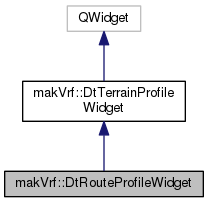
 Public Types inherited from makVrf::DtTerrainProfileWidget