Overview
This example shows how to create and install a new Coordinate Display through a plugin.
Expected Result
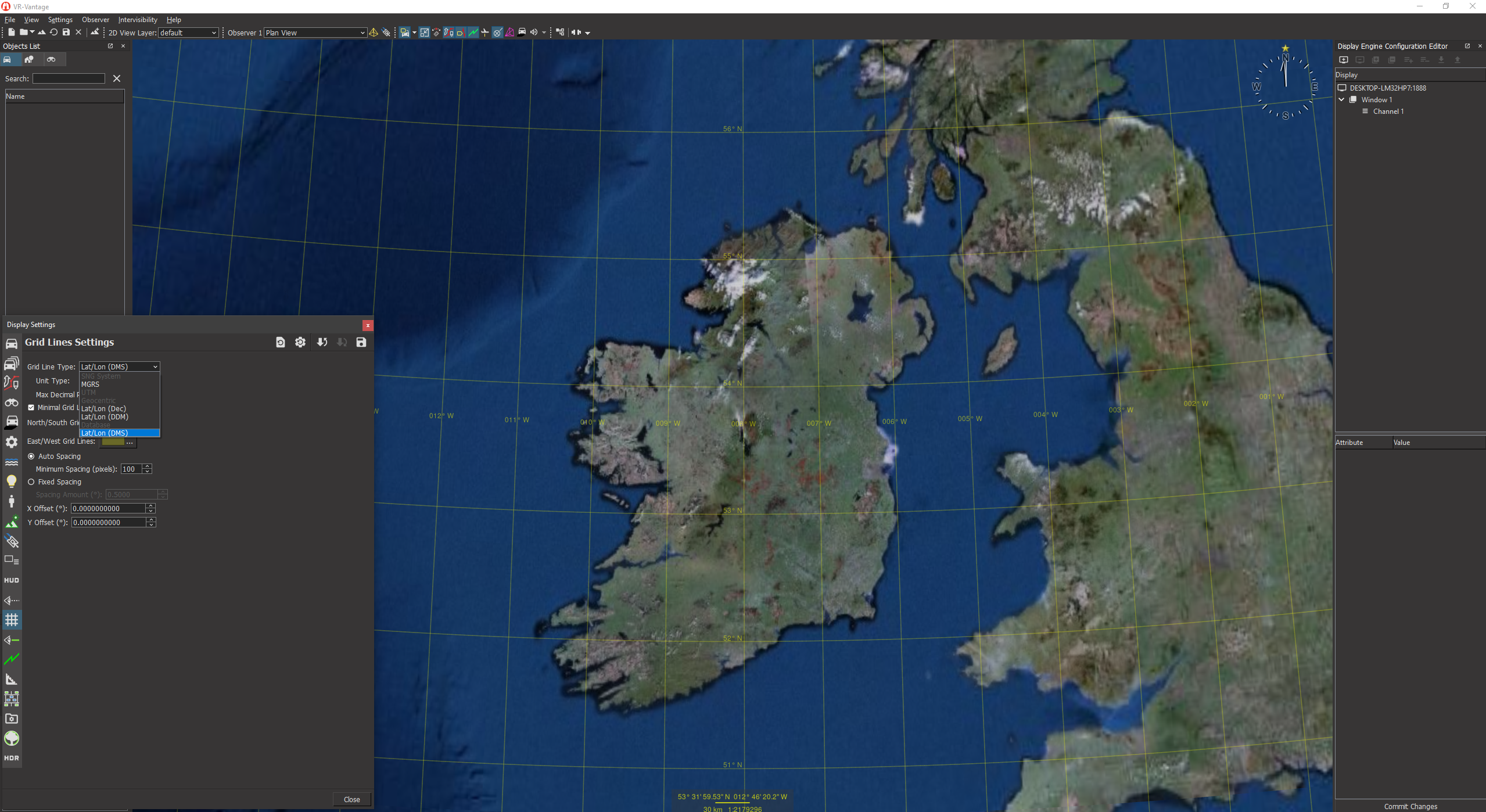
Coordinate Display Result
Example details
It implements the abstract class DtCoordinateDisplay to provide for the display of coordinates in the Swiss National Grid (CH1903) coordinate system.
The file exampleCoordinateDisplayPlugin.h sets up the necessary DLL export macros
#ifdef _WIN32
#ifdef EXAMPLECOORDINATEDISPLAY_EXPORTS
#define DT_DLL_EXAMPLECOORDINATEDISPLAYPLUGIN __declspec ( dllexport )
#else
#define DT_DLL_EXAMPLECOORDINATEDISPLAYPLUGIN __declspec ( dllimport )
#endif
#else
#define DT_DLL_EXAMPLECOORDINATEDISPLAYPLUGIN
#endif
#define DT_DE_PLUGIN_EXPORT_MACRO DT_DLL_EXAMPLECOORDINATEDISPLAYPLUGIN
The file exampleCoordinateDisplayPluginInit.cxx contains the implementation of the methods needed to initialize the plugin.
initDeModule is the method that will be called to initialize the plugin. It calls the init function and simply returns true.
using namespace makVrv;
namespace vrvExampleCoordinateDisplayPlugin
{
void installCoordinateDisplay(
DtDe& de)
{
}
The init method does the plugin initialization.
It first ensures that the plugin is only initialized once by calling the standard initialization exclusion macro:
It then checks to make sure the plugin is only initialized for master display engines:
Provided it is a master display engine, it connects the installCoordinateDisplay method to the display engine's signal_initializeDefaultState, which will be raised after the display engine's shared state has been initialized (a prerequisite for installing the coordinate display):
de.signal_initializeDefaultState.connect(boost::bind(
The installCoordinateDisplay function installs an SngCoordinateDisplayObject.
void installCoordinateDisplay(DtDe& de)
It creates an instance of an SngCoordinateDisplay and adds it to the coordinate system's list of coordinate display objects:
de.sharedState().coordinateSystem().displays().addCoordinateDisplay(
sngDisplay.h contains the declaration of the SngCoordinateDisplay class.
SngCoordinateDisplay inherits from
makVrv::DtCoordinateDisplay:
It defines a static constant to provide a numerical identifier to the type of coordinate system it displays. Note that this must be unique. In the example, we use the first available user-defined value:
Declarations are provided to override the following DtCoordinateDisplay methods:
const DtVector& geocPos, int decimals, double gridSpacing, bool minimal = false) override;
const DtVector& geocPos, int decimals, double gridSpacing, bool minimal = false) override;
DistanceUnits unit,
const DtVector& geocPos,
int decimals)
const override;
const std::string& y,
const std::string& z,
DistanceUnits distUnits,
const DtTaitBryan& geocOri ) const;
const DtTaitBryan& geocOri ) const;
const DtTaitBryan& geocOri, bool local ) const;
std::string& z );
Two protected methods unique to the class are provided for converting between SNG and WGS84 coordinates:
DtVector& OutVector);
DtVector& OutVecPos );
sngDisplay.cxx contains the implementation of these methods.
Building the Example
VR-Vantage includes pre-built versions of the example plug-in. To build it yourself, follow the instructions at Building VR-Vantage Examples, Applications, and Plug-ins.
Running the Example
This example is a plug-in. You can run it by running ./bin64/exampleCoordinateDisplay_stealth.bat (on Windows) or ./bin64/exampleCoordinateDisplay_stealth.sh (on Linux). Load "MAK Earth (online).earth" terrain, open the Observer Information Panel ("View->Observer Information Panel"), select the "SNG System" entry from the "System" dropdown box. While moving the observer, you will see the location displayed in the Observer Information Panel change based on the newly added coordinate system. Also note that in the 'Settings->Display Settings...->Grid Lines Settings' dialog page, "SNG System" is listed as an entry but it is disabled. This is because we loaded the MAK Earth (online) terrain which is a geocentric terrain. The example source code indicates the added coordinate display can only be used with grid lines when a 'Flat Earth' terrain is loaded. For more information about running examples, please see Running Applications and Examples.
Example Source Files
exampleCoordinateDisplayPlugin.h
#pragma once
#ifdef _WIN32
#ifdef EXAMPLECOORDINATEDISPLAY_EXPORTS
#define DT_DLL_EXAMPLECOORDINATEDISPLAYPLUGIN __declspec ( dllexport )
#else
#define DT_DLL_EXAMPLECOORDINATEDISPLAYPLUGIN __declspec ( dllimport )
#endif
#else
#define DT_DLL_EXAMPLECOORDINATEDISPLAYPLUGIN
#endif
#define DT_DE_PLUGIN_EXPORT_MACRO DT_DLL_EXAMPLECOORDINATEDISPLAYPLUGIN
exampleCoordinateDisplayPluginInit.cxx
using namespace makVrv;
namespace vrvExampleCoordinateDisplayPlugin
{
void installCoordinateDisplay(
DtDe& de)
{
}
{
{
&installCoordinateDisplay, std::ref(de) ));
}
}
}
{
return true;
}
sngDisplay.h
#pragma once
{
public:
const DtVector& geocPos, int decimals, double gridSpacing, bool minimal = false) override;
const DtVector& geocPos, int decimals, double gridSpacing, bool minimal = false) override;
DistanceUnits unit,
const DtVector& geocPos,
int decimals)
const override;
const std::string& y,
const std::string& z,
DistanceUnits distUnits,
const DtTaitBryan& geocOri ) const;
const DtTaitBryan& geocOri ) const;
const DtTaitBryan& geocOri, bool local ) const;
std::string& z );
protected:
DtVector& OutVector);
DtVector& OutVecPos );
};
sngDisplay.cxx
#include <matrix/vlTaitBryan.h>
#ifdef __linux__
#include <stdio.h>
#endif
#define PI 3.14159265
#define RAD2DEG(x) (x * 180/PI)
#define DEG2RAD(x) (x * PI/180)
using namespace makVrv;
{
addSupportedCSForGridLines( DtCoordinateConverter::FlatEarth );
}
{
}
{
return DtUnicode::tr("SNG System");
}
{
return DtUnicode::tr("E");
}
{
return DtUnicode::tr("N");
}
{
return DtUnicode::tr("Alt");
}
const DtVector& geocPos, int decimals, double gridSpacing, bool minimal)
{
return DtUnicode::fromAscii( lst[1] );
}
const DtVector& geocPos, int decimals, double gridSpacing, bool minimal)
{
return DtUnicode::fromAscii( lst[0] );
}
const DtVector& geocPos, int decimals) const
{
DtGeodeticCoord geodeticPosition;
geodeticPosition.setGeocentric(geocPos);
DtVector InVector(RAD2DEG(geodeticPosition.lat()), RAD2DEG(geodeticPosition.lon()), geodeticPosition.alt());
DtVector OutVector;
char buffer[256];
std::vector<std::string> results;
results.push_back(std::string(buffer));
results.push_back(std::string(buffer));
results.push_back(std::string(buffer));
return results;
}
DistanceUnits unit,
makVrv::DtUnicode unitNotation,
const DtVector& geocPos,
int decimals,
bool minimal)
const{
std::vector<DtUnicode> results;
for (std::string result : nonNotatedResult)
{
results.push_back(DtUnicode::fromAscii(result));
}
{
unitNotation = DtUnicode::fromAscii("m");
}
{
result += unitNotation;
}
return results;
}
DtVector& vector)
{
DtVector InVector( distConverter->
localToMeters( atof(x.c_str() ) ),
DtVector OutVector;
DtGeodeticCoord geod;
geod.setLat(DEG2RAD(OutVector.x()));
geod.setLon(DEG2RAD(OutVector.y()));
geod.setAlt(OutVector.z());
vector = geod.geocentric();
}
{
if ( InVecPos.x() == 0.0 && InVecPos.y() == 0.0 && InVecPos.z() == 0.0 )
{
return;
}
double lamdaTag = ( InVecPos.y() * 3600 - 26782.5 ) / 10000.0;
double lamdaTag2 = lamdaTag * lamdaTag;
double lamdaTag3 = lamdaTag2 * lamdaTag;
double phiTag = ( InVecPos.x() * 3600 - 169028.66 ) / 10000.0;
double phiTag2 = phiTag * phiTag;
double phiTag3 = phiTag2 * phiTag;
OutVecPos.setY( 200147.07 +
(308807.95 * phiTag) +
(3745.25 * lamdaTag2) +
(76.63 * phiTag2) -
(194.56 * lamdaTag2 * phiTag) +
(119.79 * phiTag3) );
OutVecPos.setX( 600072.37 +
(211455.93 * lamdaTag) -
(10938.51 * lamdaTag * phiTag) -
(0.36 * lamdaTag * phiTag2) -
(44.54 * lamdaTag3) );
OutVecPos.setZ(InVecPos.z() -
49.55 +
(2.73 * lamdaTag) +
(6.94 * phiTag) );
}
{
if ( InVecPos.x() == 0.0 && InVecPos.y() == 0.0 && InVecPos.z() == 0.0 )
{
return;
}
double yTag = ( InVecPos.x() - 600000 ) / 1000000;
double yTag2 = yTag * yTag;
double yTag3 = yTag2 * yTag;
double xTag = ( InVecPos.y() - 200000 ) / 1000000;
double xTag2 = xTag * xTag;
double xTag3 = xTag2 * xTag;
OutVecPos.setX(( 2.6779094 +
(4.728992 * yTag) +
(0.791484 * yTag * xTag ) +
(0.1306 * yTag * xTag2) -
(0.0436 * yTag3) ) *
(100.0 / 36.0) );
OutVecPos.setY(( 16.9023892 +
(3.238272 * xTag) -
(0.270978 * yTag2) -
(0.002528 * xTag2) -
(0.0447 * yTag2 * xTag) -
(0.0140 * xTag3) ) *
(100.0/36.0) );
OutVecPos.setZ( InVecPos.z() +
49.55 -
(12.60 * yTag) -
(22.64 * xTag) );
}
{
DtVector localVec;
return localVec;
}
{
}
{
}
{
x = "^-?[0-9]{1,9}\\.[0-9]{1,9}";
y = x;
z = x;
}
{
DtVector localPos;
DtTaitBryan localOri;
if ( localOri.psi() < 0 )
{
localOri.setPsi( localOri.psi() + 2 * PI );
}
return localOri;
}
{
{
return unit;
}
}
{
{
return unit;
}
}
{
{
return unit;
}
}
[<< Examples] [Home] [Top of Page]